I am reading
Madeline Bunting's The Plot again, the area in which she has written the biography of her father which is fascinating. He bought an acre of land, accessed along an old trackway, the field had once been the site of a farm, and it is here that he built a 'chapel' which housed his scuptures, his wife and five children lived in the village of Oldstead about a mile away.
What catches my attention is the landscape round this part of Yorkshire, Sutton Bank, a cliff that rises sharply out of the land from one of the the longest village names Sutton-Under-Whitestonecliff, now the cliff is clothed in trees. It is on the A170 to the town of Thirsk, in fact the road we travelled when we went to collect Lucy from the dog rescue centre, and we stopped off and shared our ham sandwiches with her.
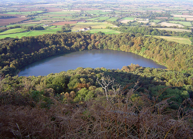
Under Sutton Bank is this naturally formed lake called Gormire, (translated as 'filthy swamp) difficult to get down to, and with legends such as that it is very deep, though this is not true. It seemed to have been formed from the melting of a glacial, it has no feeding river or stream but its water remains fairly constant. and apparently full of leeches if you go swimming. One legend has it that a rider's white horse bolted over the bank into the lake, and he can still be heard at night grooming his horse. Another tale tells of a knight challenged to a race along the bank by the abbot of Rievalaux, borrowed a white horse from the abbot and was taken by the horse over the top of the cliff, the knight turning to look at the abbot saw that he had changed into the devil!
 |
| Gormire Lake; https://creativecommons.org/licenses/by-sa/2.0/ |
Another topographical feature of the landscape is Hood Hill, which apparently had a medieval castle at its crown.... and now for our print of Sutton Bank that hangs on the wall to contrast ..... Well I see Hood Hill and is that
Roulston Scar in front I wonder, the lake to the left.
 |
| Hood Hill; cc. @ http://www.geograph.org.uk/photo/863200 |
Not too far away is
Bylands Abbey and Rievaulax Abbey, there is a definite 'religious' feel to the area with the Catholic Ampleforth College not too far away. Then there is Oswaldkirk and Easingwold, all very Scandinavian and religious. Somewhere under all that bracken and trees is an Iron Age fort dominating the scene, it is almost a physical boundary this great cliff delineating territory.
What caught my attention though were three Victorian 'antiquarians' Canon Jackson, the Reverend Atkinson and someone called Mortimer. They laid bare several hundred Bronze Age barrows, until their foolhardiness was questioned, Canon Jackson got thrown off one estate for making such a mess of the barrows he was supposely 'excavating'. All the goods that were found were later sold on for profit, but luckily the American collectors who bought them donated them to the British Museum.
Dorothy and William Wordsworth rode or walked along Sutton Bank to Helmsley, stopping at the Black Swan Inn once, and then also to Thirsk. Dorothy writes
"We had not wanted fair prospects before us as we drove along the flat plain of the high hill. Far, far off us in the western sky we saw the shapes of castles, ruins among groves, a great spreading wood, rocks and single trees, a minster with its tower unusually distinct, minarets in another corner and a round Grecian temple... as we descended the hill there was no distinct view but of a great space; only near us we saw the wild snd (as people say) bottomless tarn... it seemed to be made visible only by its own light, for all the hill about us was dark"
Inside the North York Moors - Harry Mead


